Every successful renovation, restoration, retrofit or redevelopment project begins with one essential step i.e. understanding the existing structure accurately. This is where architectural surveys play a critical role.
Architectural surveys provides the precise information about a building’s dimensions, layout, structural elements and existing conditions. They serve as the foundation for design development, planning, actual construction and post construction, i.e. facility management. Without accurate survey data, projects can face design conflicts, costly reworks, delays and coordination issues.
As modern construction projects becomes increasingly complex, architectural surveys have evolved from traditional manual measurements to advanced digital data capture techniques thus enabling faster, more accurate and highly detailed documentation.
What Is an Architectural Survey?
An architectural survey is the process of collecting and documenting accurate information about an existing building or site.
The survey records critical details such as:
- Building dimensions
- Floor layouts
- Elevations and sections
- Structural components
- Ceiling and roof details
- Openings, doors and windows
- MEP elements
- Material conditions
- Site constraints
The information gathered during the survey is then converted into drawings, CAD files or BIM models for further design and construction activities.
Architectural surveys are commonly conducted for:
- Renovation projects
- Adaptive reuse developments
- Heritage restoration
- Facility upgrades
- Interior remodeling
- Building extensions
- As-built documentation
- Asset management
Why Are Architectural Surveys Important?
Architectural surveys helps the project stakeholders to make informed decisions based on the actual site conditions rather than just assumptions or outdated drawings.
Accurate Existing Condition Documentation
Many older buildings either lack proper documentation or have drawings that no longer reflect the current conditions. Surveys provide updated and reliable records that supports accurate planning and design.
Improved Design Coordination
Survey data helps the architects, engineers and contractors to coordinate more effectively by identifying the structural constraints, service locations and dimensional variations early in the project.
Reduced Construction Risks
Accurate measurements minimizes the risk of clashes, reworks and on-site errors during the construction or renovation activities.
Better Project Planning
Architectural surveys provide essential inputs for budgeting, scheduling, material estimation and feasibility studies.
Enhanced Renovation and Retrofit Efficiency
For renovation and retrofit projects, understanding the existing structure is critical. Surveys helps the teams to integrate the new systems and designs into existing buildings more efficiently.
Types of Architectural Surveys
Different project requirements calls for different types of architectural surveys.
Measured Building Surveys
These surveys captures the accurate measurements of the building’s geometry and spatial layout. They typically include floor plans, elevations and cross-sections.
Condition Surveys
Condition surveys assess the physical condition of a structure, identifying damage, deterioration or maintenance requirements.
Topographical Surveys
These surveys documents the site features such as terrain, utilities, drainage systems, roads, vegetation and surrounding infrastructure.
As-Built Surveys
As-built surveys reflects the actual constructed condition of a building after the project completion, including any modifications made during the construction.
Heritage Surveys
Used for historical or protected structures, heritage surveys capture the architectural details, ornamental elements and structural conditions for preservation purposes.
How Are Architectural Surveys Prepared?
Architectural surveys follows a systematic process that combines field data collection with the digital documentation and modeling technologies.
Initial Project Assessment
The process begins with understanding the project scope, building type, survey requirements and desired deliverables. Teams determine the level of detail required based on the project objectives.
Site Inspection and Data Collection
Survey teams visit the site to capture the measurements, photographs, spatial relationships and building conditions. Depending on the project’s complexity, they may use:
- Total stations
- Laser scanners
- Drones
- GPS equipment
- Digital measuring tools
Modern surveying increasingly relies on laser scanning technology to capture the highly accurate spatial data in a short time.
Point Cloud Generation
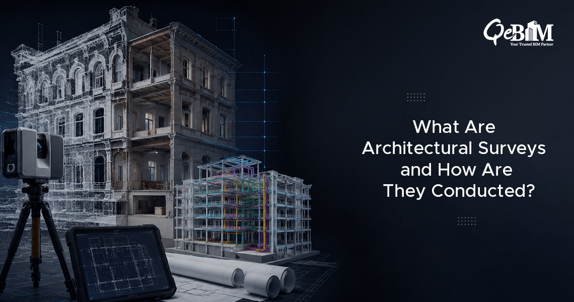
Laser scanners captures millions of data points that collectively creates a digital representation of the building known as a point cloud.
This process has significantly improved the speed and precision of surveys, especially for the large-scale or complex structures. Using Point Cloud to BIM Services, these scanned datasets can be converted into intelligent BIM models that supports the design coordination, renovation planning and facility management workflows.
Data Processing and Verification
The captured survey data is processed and verified to ensure accuracy and completeness. Teams identifies the inconsistencies, missing information or alignment issues before any documentation begins.
CAD Drafting and BIM Modeling
The processed data is then transformed into:
- 2D architectural drawings
- CAD files
- 3D BIM models
- As-built documentation sets
These outputs helps the architects, engineers, contractors and facility managers to work with the reliable building information throughout the project lifecycle.
Final Documentation and Deliverables
The final survey package may include:
- Floor plans
- Roof plans
- Elevations
- Sections
- Reflected ceiling plans
- Site plans
- BIM models
- Detailed reports
Many firms also integrate Construction Documentation Services to create coordinated construction-ready drawing packages from the survey data.
Technologies Transforming Architectural Surveys
Technology has dramatically improved the efficiency and accuracy of architectural surveying processes.
3D Laser Scanning
3D laser scanning captures the precise measurements and complex geometries with exceptional speed and accuracy.
Drones and Photogrammetry
Drones helps in capturing the inaccessible areas such as roofs, façades and large sites while reducing the safety risks.
Building Information Modeling (BIM)
BIM enables survey information to be integrated into intelligent digital models that supports design, coordination, visualization and lifecycle management.
Cloud-Based Collaboration
Modern survey workflows allows the project teams across multiple locations to access, review and coordinate survey data in real time.
Challenges in Architectural Surveys
Despite technological advancements, architectural surveys can still present several challenges:
- Limited site accessibility
- Complex geometries
- Incomplete historical records
- Occupied buildings
- Tight project timelines
- Data management complexity
Experienced survey and BIM teams helps to overcome these challenges through structured workflows, advanced technologies and quality control processes.
The Future of Architectural Surveys
Modern architectural surveys are increasingly powered by digital technologies, automation, and intelligent data capture. Emerging technologies such as AI-powered processing, digital twins, reality capture and automated modeling are transforming how the buildings are documented and managed.
As the AEC industry moves towards smarter construction and lifecycle-based asset management, accurate survey data will continue to play a foundational role in project success.
Conclusion
Architectural surveys are far more than simple measurements. They provide the critical information required to design, renovate, construct and manage the buildings effectively. From traditional measured surveys to advanced laser scanning and BIM workflows, modern surveying methods delivers the precision and efficiency needed for today’s complex construction projects.
By combining accurate data capture with the digital modeling and documentation technologies, architectural surveys helps to reduce the project risks, improve coordination and support better decision-making throughout the building lifecycle.